
Turn Your Map-Making Into a Fun Adventure: Introduction of the Field Papers Through Youth Participation at the Universitas Pendidikan Indonesia
- Fikri Irvansyah || UPI YouthMappers || Universitas Pendidikan Indonesia
- Aug 13, 2024
- 3 min read
Updated: Jan 9
Introduction
As we enter our fourth year, Universitas Pendidikan Indonesia continues to enhance and upgrade educational quality through the development of infrastructure and facilities at the Bumi Siliwangi campus. Through the Advanced Knowledge and Skills for Sustainable Growth project, funded by the Asian Development Bank. This development has resulted in six new buildings including FPSD, FPTK, CoE, FPEB, SPS, and the Professional Teacher Education and Training Centre. Therefore, some OSM data presented on the website may not accurately reflect current conditions, with the latest data we checked dating back to 2019. This could impact users intending to utilize OSM data. Driven by the local knowledge and enthusiasm of UPI students, and motivated by the need for updated OSM data, we are initiated a project called 'Campus Mapping' on March 16, 2024.
Let's get to know Field Papers

Lines in red are drawn using a marker to annotate buildings and roads on atlas field papers.)
Field Papers is a tool that helps you to collect data in the field, this tool was developed by OSM. It's quite easy to use and the sketches are georeferenced automatically. The sketch results in the atlas will be used as a custom background. (Find more information about Field Papers, https://learnosm.org/en/mobile-mapping/field-papers/).
.


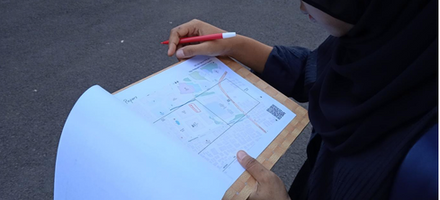
Standing in the middle of the road, Faridza looked at her Field Papers to sketch any changeset (building or road) based on her observation
While carrying colorful markers and 'field papers' printouts, we explored our campus and sketched any changes (building or road) on the atlas. Two groups collected field data then everyone discussed their observations and the meaning of the symbols sketched on the atlas. We were accompanied by Pak Andi (Kaart), who provided advice and information on how to use tags/keys correctly.


Day 2
Under the stars and moonlight that illuminates the night of Bandung on Wednesday, 19 June 2024. Via video conferencing, we uploaded scanned 'field papers' sketches to the website and learned how to digitize them using id-editor.

Found the Bug
Sometimes someone sees a website that suddenly can't be accessed or some tabs aren't running. This is normal in the digital world, as long as it is fixed quickly.
This case happened to us too. We couldn't upload the atlas page at all, only a few were successful. So, we thought that there was a bug on this website, and I immediately reported it to the web developers via email. Nevertheless, we found a way out and continued editing via iD with a split screen.

Result

Screenshot from the website https://overpass-api.de/achavi/ which shows the changeset during day 2 field paper data editing activities via iD
We found several OSM POIs that did not match in the field and old data. Among them were incorrectly used keys: name, unseen road, and we also added new building, road, steps, and park. There are 18 changesets from day 2. This was a good achievement even though we are new to Field Papers.
Acknowledgment
Through this activity, we developed precise and up-to-date campus geospatial data. Without awareness and the need for the latest open data, users who use the data, such as for navigation or looking for addresses, could get lost in the campus area.
The list of participants is as follows:
* Faridza from SaIG 23
* Syuhada from SaIG 22
* Fajar from SaIG 22
* Fikri Irvan from SaIG 20

Hopefully, in the future, this little contribution can inspire UPI students and other students from universities worldwide to continue editing, validating, and maintaining the quality of OSM data. Through local knowledge about neighborhood, it can have a big impact to everyone if we are participating in open mapping.

Autor
Fikri Irvansyah is a student of Geographic Information Science (SaIG) at Universitas Pendidikan Indonesia. He is the Co-founder of the UPI YouthMappers and is passionate about using geospatial technologies for community development and disaster response.
Reach me at beyirvan@gmail.com
Comments