Generating Open Data with the Community to Strengthen Flood Resilience in Nueva Villa La Iguaná, Medellín
- Sara Berrio and Paulino Rendón
- Nov 8, 2024
- 3 min read
Updated: Jan 8
The project "Participatory Mapping for Flood Resilience in Nueva Villa La Iguaná" was partially funded by the Integrated Drought and Flood Management Program of the Global Water Partnership. The team was led by Yessica de los Ríos and included two members from the GeoLab chapter, Paulina Rendón and Sara Berrio, as well as two members from the SAGEMA chapter, Estefanía Garcés and Camilo Castaño.
The overall objective of the project was to contribute to flood resilience through the use of participatory mapping tools. The project was developed in four phases: Introduction to Mapping, Neighborhood Mapping, Mapping and Vulnerability, and finally, Open Data and Resilience. Each phase is documented in a YouTube playlist.
Workshops Conducted by YouthMappers
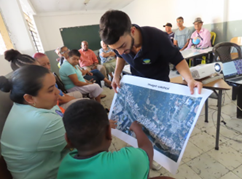
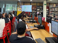
The workshops conducted by YouthMappers provided a valuable opportunity to engage with the community, which included young people and adults actively involved in the community action board. These workshops covered topics such as collaborative mapping, creating open data in OpenStreetMap, understanding risk concepts (vulnerability, exposure, and resilience), territory, socio-ecosystems, and various open tools. We focused on creating dynamic activities that facilitated the understanding of these concepts, overcoming the challenge of communicating them effectively without overwhelming the participants.
These workshops encouraged the community to recognize their territory by engaging in mapping and generating open data. Additionally, they introduced the community to various open tools, enabling them to continue gathering data and using this information to enhance their flood resilience.
Challenges and Opportunities During the Mapping Phase
One of the primary challenges we faced was the need for higher resolution images due to the area being a densely populated settlement. To address this, we received support from the Humanitarian OpenStreetMap Team, which provided a drone to capture images of the neighborhood. We processed these images using the open tool OpenDroneMap, a service offered by the OSM Latam community, and obtained an orthophoto of the neighborhood hosted on OpenAerialMap.
YouthMappers also provided resources for two students to take a drone pilot course, giving us greater flexibility to create orthophotos for future projects.
Although the high-resolution orthophoto allowed us to perform an initial remote mapping, we encountered limitations in adding detailed information to the map. This made field mapping necessary, which included adding attributes to buildings and mapping paths and alleys that were not visible in the aerial images. This experience enabled us to explore and test various tools and applications in the area, such as Mapillary, FieldPapers, Vespucci and StreetComplete, KoboToolbox. By doing so, we were able to discard less accurate tools and combine others to achieve more comprehensive mapping results.
We are currently documenting this process for future publication as a model for data collection in similar settlements. This will allow the YouthMappers community to replicate this methodology or use it to support mapping in other areas with similar characteristics.
This data collection model enabled us to map approximately 626 buildings, containing around 1,823 housing units within the neighborhood. Additionally, we mapped 1.4 kilometers of walkways and alleys, 45 commercial premises, and 92 key elements in a flood event, such as culverts and poles. This comprehensive cartographic base is a valuable resource for the community, enabling them to implement actions to increase their flood resilience and develop community risk management plans with the support of local authorities.


Data that contribute to resilience
The final phase of the project aimed to provide more relevant information about flood events through a community survey conducted in the most flood-affected area. This survey was carried out using the open tool KoboToolbox. Although it does not directly upload to OSM, it can be integrated through geoprocessing in QGIS. This was another significant learning experience in data processing and visualization for our training.
The information collected was analyzed in our last workshop during a roundtable discussion with key local authorities, such as the Administrative Department of Disaster Risk Management (DAGRED), the Early Warning System (SIATA), and the community. This not only allowed us to visualize open data that benefits the community but also helped consolidate our identity as a YouthMappers community and establish connections for future mapping work as a tool for risk management.

Lessons Learned and Reflections
This project allowed us to confront various challenges, think creatively, and improve our technical mapping skills. We had the experience of working with a community that has witnessed changes in their neighborhood from multiple perspectives, allowing us to integrate local knowledge with our technical mapping expertise. We are grateful to the project leader for guiding us through this learning process and encouraging us to document our experience so that it can be replicated in other areas in need of similar interventions.
Written by:

Sara Berrio – Sanitary Engineering Student, GeoLab YouthMappers Chapter, University of Antioquia

Paulina Rendón – Environmental Engineering Student, GeoLab YouthMappers Chapter, University of Antioquia


This is great and amazing work! Keep it up, and I'm always proud of you all for uplifting YouthMappers around the globe.