
An Introduction to Open-Source Mapping for Beginners
- Ishak Alam Pir
- Mar 20
- 4 min read
The views and content expressed in this blog are those of the author(s) and do not necessarily reflect the positions or policies of any organization. YouthMappers is a voluntary network, and all participation in its activities is independent and self-directed. Any projects, data, or findings referenced here are the result of voluntary contributions from YouthMappers members.
An Introduction to Open-Source Mapping for Beginners
Mapping can seem daunting at first glance, especially if you're a beginner. I recall being in awe when I made my first map; it was like learning about a whole new realm of geographic data and data collection. That was just the beginning of my journey into open-source mapping and community building.

To map the future together, we YouthMappers at the IRS Jahangirnagar University chapter took the initiative to train 30 students to create their very first map. "A Beginner’s Guide to QGIS & OpenStreetMap" was a one-day session that changed our perspective on novices and their possibilities. I could see myself through them; as soon as they created their first map, the light on their faces was incredibly rewarding—not just for them, but for us as organizers too. It was a powerful reminder of how open-source mapping can unlock creativity and inspire real change.

The students were blessed with the presence of Program Chair Professor Dr. Mohammad Nazrul Islam, who inaugurated the workshop. Professor Dr. Md. Nurul Islam, the National University's Pro-Vice-Chancellor, also gave a presentation. Their motivational speeches encouraged everyone to embrace the globalization of technology, especially in the geospatial arena.
OpenStreetMap (OSM): The Open-Source Mapping Ecosystem
The easy accessibility, versatility, and community-based approach are revolutionizing OSM data in the mapping world. As a free, open-source resource, OSM empowers users to contribute and access high-quality geospatial data without restrictions. It serves as a catalyst for innovation within the open-source mapping community.
Participants were guided step by step to create their OSM accounts, unlocking the gateway to an effective global mapping community. By introducing the essentials, participants engaged in hands-on exposure to editing tools for beginners, giving them entry into the art of digital cartography.
The instructor was Subrata Debnath, an open-mapping guru from "Open Mapping Hub - Asia Pacific," who boosted the momentum with practical exercises and helped participants translate theory into action. In the beginning, he instructed them on how to edit various features in OSM, then how to create different types of shapefiles one by one. After gaining some basic expertise in OSM, he then instructed them on the most important part: how to extract the shapefile of the study area, which would later be used in QGIS for mapping—another open-source tool for mapping.

Some of our volunteers played a crucial role in helping participants maintain quality control and accuracy while practicing OSM. At the end, the instructor showcased the usefulness of using OSM data and encouraged participants to stay connected, curious, and creative with the OSM ecosystem.
One of the participants, Mehedi Hasan Shuvo, expressed his gratitude after the OSM session. He said, “Learning to use OSM and export data from it is really very simple, and it feels intuitive and empowering, as it provides an efficient way to access and utilize spatial data for various projects.”
QGIS: A Silver Bullet Open Source for Mapping
QGIS, a powerful open-source tool for mapping and GIS analysis, has built-in OSM integration, allowing users to directly access, edit, and style OSM data to create visually stunning and highly functional maps.
Zobaer Rahman, one of our open-mapping gurus from "Open Mapping Hub - Asia Pacific" and the president of our chapter, led the journey with QGIS, introducing it as one of the most versatile open-source GIS powerhouses. Participants gained hands-on experience working with spatial data through a live demonstration.
A hands-on exercise began with navigating the map canvas in QGIS. Every participant inputted the shapefile and other data into QGIS that had just been extracted from OSM. Then, they learned basic symbology and styling, which enabled them to create eye-catching maps.
The session was so interesting and interactive, with participants asking many questions and overcoming their doubts and fears. After making some basic edits to vector data, they reached the final stage of map composition. All the attendees were excited to see their final map layouts. Then, inputting essential map elements—like titles, north arrows, legends, scale bars, and borders—resulted in the complete outcome of the last two-hour session.

One of the participants, Mst. Ausmaul Husna Shemonty, shared a gratifying reflection at the end of the session. She said, “The QGIS session provided valuable skills for visualizing spatial data, which are highly relevant to research and decision-making in my academic field. In the future, I plan to apply this knowledge to create detailed maps and perform geospatial analysis to support projects and studies.”
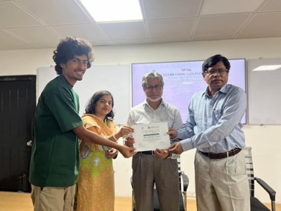
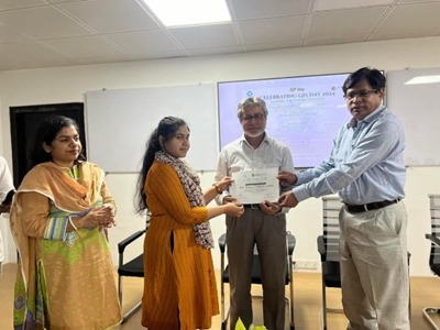
The Certification Ceremony
The concluding part of the event included a certification ceremony, where participants were rewarded for their enthusiasm and commitment throughout the sessions. Professor Dr. Md. Nurul Islam, Pro-Vice-Chancellor of National University, Dr. Mohammad Nazrul Islam, Program Chair, and Toma Rani Saha attended the ceremony and presented certificates to the attendees. Their encouraging words and inspiration elevated the satisfaction level among the workshop participants.


I believe this learning experience has introduced the participants to a new world where they will witness significant changes for themselves and their communities. It was a tremendous experience for me to work as a coordinator in this workshop. We must appreciate the efforts of our entire team in successfully completing this event.
Also, the support provided by our advisors from the beginning was unparalleled. Such small events may not bring about change overnight, but these meaningful initiatives will help us make a lasting impact one day.

About the Author
Ishak Alam Pir is an Environmental Sciences student at Jahangirnagar University and general secretary of YouthMappers at IRS Jahangirnagar University chapter. He is a second-place winner in the Road Mapping segment of Open Mapping Hub - Asia Pacific’s competition, Ishak also regularly edits and enhances OpenStreetMap. With a strong passion for the geospatial arena and voluntary work, he has been actively engaged in the YouthMappers chapter.
Photos by Shahed Anan Sajeeb, Assistant General Secretary YouthMappers at IRS Jahangirnagar University Chapter,2024-2025.
Connect with the chapter here.
Comments